United Kingdom Volcanoes
-

Soufriere Hills
-

Soufriere Hills
-
Candlemas Island
-
Soufriere Hills
-
Zavodovski
-

Bristol Island
-
Soufriere Hills
-
Bristol Island
-
Zavodovski
-
Soufriere Hills
-
Soufriere Hills
-
Leskov Island
-
Soufriere Hills
-
Soufriere Hills
-
Candlemas Island
-
Soufriere Hills
-
Soufriere Hills
-
Soufriere Hills
-
Soufriere Hills
-
Soufriere Hills
United Kingdom has 14 Holocene volcanoes. Note that as a scientific organization we provide these listings for informational purposes only, with no international legal or policy implications. Volcanoes will be included on this list if they are within the boundaries of a country, on a shared boundary or area, in a remote territory, or within a maritime Exclusive Economic Zone. Bolded volcanoes have erupted within the past 20 years. Suggestions and data updates are always welcome ().
| Volcano Name | Location | Last Eruption | Primary Volcano Type |
|---|---|---|---|
| Adams Seamount | Central Pacific Ocean | 50 BCE | Lava dome |
| Ascension | Atlantic Ocean (central) | 1508 CE | Stratovolcano |
| Bristol Island | South Sandwich Islands (UK) | 2016 CE | Stratovolcano |
| Candlemas Island | South Sandwich Islands (UK) | 1911 CE | Stratovolcano |
| Hodson | South Sandwich Islands (UK) | Unknown - Evidence Credible | Stratovolcano |
| Leskov Island | South Sandwich Islands (UK) | Unknown - Unrest / Holocene | Stratovolcano |
| Montagu Island | South Sandwich Islands (UK) | 2007 CE | Shield |
| Nightingale Island | Atlantic Ocean (southern) | 2004 CE | Stratovolcano |
| Protector Seamounts | South Sandwich Islands (UK) | 1962 CE | Volcanic field |
| Saunders | South Sandwich Islands (UK) | 2013 CE | Stratovolcano |
| Soufriere Hills | Montserrat | 2013 CE | Stratovolcano |
| Southern Thule | South Sandwich Islands (UK) | 1975 CE | Stratovolcano(es) |
| Tristan da Cunha | Atlantic Ocean (southern) | 1962 CE | Shield |
| Zavodovski | South Sandwich Islands (UK) | 2016 CE | Stratovolcano |
Chronological listing of known Holocene eruptions (confirmed or uncertain) from volcanoes in United Kingdom. Bolded eruptions indicate continuing activity.
| Volcano Name | Start Date | Stop Date | Certainty | VEI | Evidence |
|---|---|---|---|---|---|
| Bristol Island | 2016 Apr 24 | 2016 Jul 26 | Confirmed | 1 | Observations: Reported |
| Zavodovski | 2016 Mar 30 | 2016 Jun 15 ± 15 days | Confirmed | 1 | Observations: Reported |
| Saunders | 2014 Nov 12 | 2024 Apr 19 (continuing) | Confirmed | 1 | Observations: Reported |
| Soufriere Hills | 2005 Apr 15 | 2013 Feb 5 | Confirmed | 3 | Observations: Reported |
| Nightingale Island | 2004 Jul 29 | 2004 Jul 30 | Confirmed | 0 | Observations: Reported |
| Soufriere Hills | 2004 Mar 3 | 2004 May 2 | Confirmed | 3 | Observations: Reported |
| Montagu Island | 2001 Oct 1 ± 20 days | 2007 Sep 20 | Confirmed | 1 | Observations: Reported |
| Saunders | 2000 May 13 | 2013 Nov 16 | Confirmed | 0 | Observations: Reported |
| Saunders | 1999 Jan 19 | 1999 Jan 19 | Confirmed | 0 | Observations: Reported |
| Montagu Island | [1996 Sep 1 ± 180 days] | [Unknown] | Uncertain | ||
| Soufriere Hills | 1995 Jul 18 | 2003 Oct 8 | Confirmed | 3 | Observations: Reported |
| Saunders | 1995 Apr 16 (?) ± 15 days | 1998 Feb 16 (in or after) ± 15 days | Confirmed | 0 | Observations: Reported |
| Saunders | 1989 Jan 30 | 1990 Mar 22 | Confirmed | 0 | Observations: Reported |
| Southern Thule | 1975 Jul 2 ± 11 years ± 182 days | Unknown | Confirmed | 1 | Observations: Reported |
| Protector Seamounts | 1962 Mar 5 | 1962 Mar 5 | Confirmed | 1 | Observations: Seismicity |
| Tristan da Cunha | 1961 Oct 10 | 1962 Mar 15 | Confirmed | 2 | Observations: Reported |
| Bristol Island | 1956 Jan 11 | 1956 Jan 19 (?) | Confirmed | 3 | Observations: Reported |
| Candlemas Island | [1953 Dec 31 ± 365 days] | [Unknown] | Uncertain | ||
| Bristol Island | 1950 Mar 27 | Unknown | Confirmed | 2 | Observations: Reported |
| Bristol Island | 1936 Dec 18 | 1937 Jan 1 (?) | Confirmed | 2 | Observations: Reported |
| Bristol Island | 1935 Dec 31 | Unknown | Confirmed | 2 | Observations: Reported |
| Hodson | [1930] | [Unknown] | Uncertain | ||
| Candlemas Island | 1911 Nov 6 | Unknown | Confirmed | 2 | Observations: Reported |
| Zavodovski | [1908 Nov] | [Unknown] | Uncertain | ||
| Saunders | 1900 ± 10 years | Unknown | Confirmed | 0 | Correlation: Tephrochronology |
| Hodson | [1830 Sep 22] | [Unknown] | Uncertain | ||
| Zavodovski | [1830 Sep] | [Unknown] | Uncertain | ||
| Zavodovski | [1823] | [Unknown] | Uncertain | ||
| Candlemas Island | 1823 | Unknown | Confirmed | 2 | Observations: Reported |
| Bristol Island | 1823 | Unknown | Confirmed | 2 | Observations: Reported |
| Saunders | [1823] | [Unknown] | Uncertain | ||
| Saunders | 1819 Dec 29 | Unknown | Confirmed | 2 | Observations: Reported |
| Zavodovski | 1819 Dec | Unknown | Confirmed | 2 | Observations: Reported |
| Tristan da Cunha | 1700 ± 50 years | Unknown | Confirmed | Correlation: Tephrochronology | |
| Soufriere Hills | 1550 ± 50 years | Unknown | Confirmed | Isotopic: 14C (calibrated) | |
| Ascension | 1508 ± 180 years | Unknown | Confirmed | 0 | Isotopic: Ar/Ar |
| Soufriere Hills | 1480 ± 50 years | Unknown | Confirmed | Isotopic: 14C (calibrated) | |
| Ascension | 1468 ± 120 years | Unknown | Confirmed | 0 | Isotopic: Ar/Ar |
| Soufriere Hills | 1180 (?) | Unknown | Confirmed | Isotopic: 14C (uncalibrated) | |
| Ascension | 0378 ± 370 years | Unknown | Confirmed | 0 | Isotopic: Ar/Ar |
| Adams Seamount | 0050 BCE ± 1000 years | Unknown | Confirmed | 0 | Isotopic: K/Ar |
| Adams Seamount | 1050 BCE ± 1000 years | Unknown | Confirmed | 0 | Isotopic: K/Ar |
| Candlemas Island | 1250 BCE (?) | Unknown | Confirmed | Sidereal: Ice Core | |
| Soufriere Hills | 2460 BCE ± 70 years | Unknown | Confirmed | Isotopic: 14C (calibrated) | |
| Adams Seamount | 4050 BCE ± 2000 years | Unknown | Confirmed | 0 | Isotopic: K/Ar |
| Soufriere Hills | 4050 BCE (?) | Unknown | Confirmed | Correlation: Tephrochronology | |
| Adams Seamount | 5050 BCE ± 1000 years | Unknown | Confirmed | 0 | Isotopic: K/Ar |
| Soufriere Hills | 8050 BCE ± 2000 years | Unknown | Confirmed | Isotopic: 14C (calibrated) |
United Kingdom has 5 Pleistocene volcanoes. Note that as a scientific organization we provide these listings for informational purposes only, with no international legal or policy implications. Volcanoes will be included on this list if they are within the boundaries of a country, on a shared boundary or area, in a remote territory, or within a maritime Exclusive Economic Zone. Suggestions and data updates are always welcome ().
| Volcano Name | Location | Primary Volcano Type |
|---|---|---|
| Centre Hills | Montserrat | Lava dome(s) |
| Gough Island | Atlantic Ocean (southern) | Shield |
| Inaccessible Island | Atlantic Ocean (southern) | Stratovolcano |
| Pitcairn | Pacific Ocean (central) | Shield |
| Silver Hills | Montserrat | Lava dome(s) |
There are 59 photos available for volcanoes in United Kingdom.
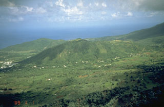
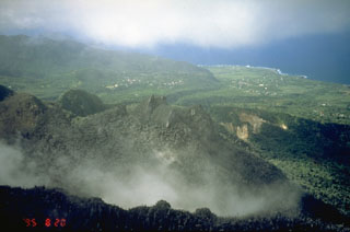
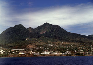
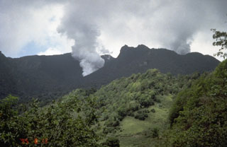
 During more pleasant days, Soufrière Hills volcano rises above the outskirts of Plymouth (lower right), the capital city of Montserrat, known as the Emerald Isle. Two decades after the date of this 1977 photo, pyroclastic flows from a growing lava dome swept through the center of the evacuated city of Plymouth.
Photo by Richard Fiske, 1977 (Smithsonian Institution).
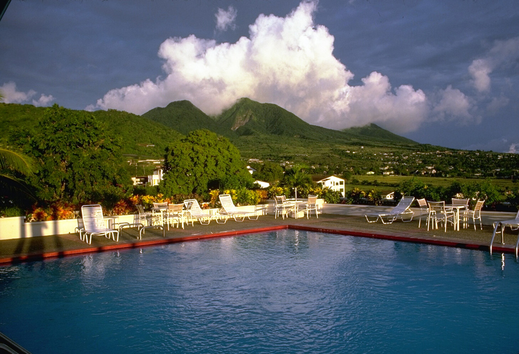
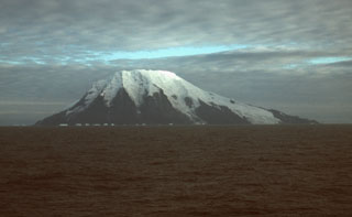
 The southwest side of Tristan da Cunha volcano rises above the southern Atlantic ocean. The summit cone Queen Mary’s Peak towers above high cliffs along most of the 12-km-wide island. Lava flows dominate both the low-angle base and the steep upper flanks, although pyroclastic cones ringing the central cone are scattered around the lower flanks. An eruption in 1961 occurred from a vent on the northern coast, just east of the island's only settlement, Edinburgh of the Seven Seas, forcing its evacuation.
 Photo by Vicky Hards, 2004 (British Geological Survey, copyrighted NERC).
 Three generations of lava-dome growth can be seen in this January 27, 1997 aerial photo of Soufrière Hills volcano. Ash is venting from a small dome that began growing in December 1996 within a scarp formed by collapse of an October 1996 lava dome. The October dome in turn was constructed within a scarp whose southern wall forms the cliff at the lower left. This outer scarp was formed by collapse of a pre-September 1996 lava dome.
 Photo by Mark Davies, 1997 (Montserrat Volcano Observatory).
 The south moat of English's Crater is seen here from the east on September 2, 1995. A blanket of ash covers Castle Peak lava dome (right) and the walls of English's Crater. Steam rises from a vent on the SW side of the lava dome that formed on July 28. A new lava dome began growing in November 1995. It eventually grew above the crater rim and filled in most of the moat of English's crater. Pyroclastic flows initially swept into the sea through the breached eastern end of English's Crater, but later overtopped its rim and flowed down the outer flanks.
Photo by Cynthia Gardner, 1995 (U.S. Geological Survey).
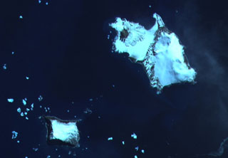
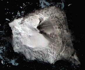
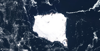 The glaciated 12 x 12 km Montagu Island in the South Sandwich Islands is shown in this 2 December 2019 Sentinel-2 satellite image (N is at the top). The highest point is Mount Belinda near the northern coastline with the dark crater apparent here, which appears to have formed within a 6-km-diameter, ice-filled caldera. The SE peninsula is Mount Oceanite.
Satellite image courtesy of Copernicus Sentinel Data, 2019.
 St. George's Hill (center) and Garibaldi Hill (along the coast to the left) are two Pleistocene lava domes on the NW flank of Soufrière Hills volcano. Pyroclastic flows from a lava dome growing in the summit crater flowed down the NW flank beginning in August 1997 and banked up against St. George's Hill before turning to the left and sweeping into the sea through the center of Plymouth, the capital city of the island of Montserrat. This aerial photo was taken in August 1995 from above the west flank of the volcano.
Photo by Cynthia Gardner, 1995 (U.S. Geological Survey).
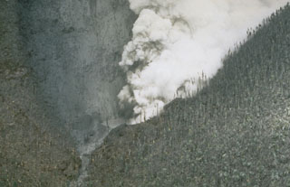
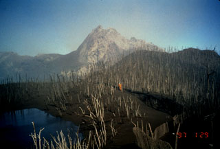
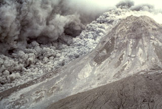
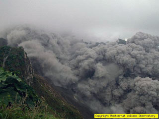
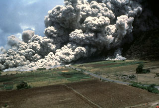 A devastating pyroclastic flow on 25 June 1997 sweeps across the lower NE flank of Soufrière Hills volcano on Montserrat. More than two dozen people within the officially evacuated zone were killed. This eruption sent an ash plume to ~10 km altitude and produced pyroclastic flows and surges that overran both vacated and partly inhabited NE-flank settlements, destroying 100-150 houses in eight villages within the restricted zone. The pyroclastic flow traveled 4.5 km and almost reached the sea.
Photo by Paul Cole, 1997 (Montserrat Volcano Observatory).
 A pyroclastic flow sweeps down the floor of the Tar River valley on the eastern flank of Soufrière Hills volcano on January 16, 1997. The Tar River Estate house, which had been damaged by earlier eruptions, is the white dot on the ridge at right center. The January 16 pyroclastic flow was the largest to date during the eruption. The pyroclastic flow traveled about 3.5 km into the sea beyond the new delta formed at the mouth of the Tar River valley.
 Photo by Richard Herd, 1997 (Montserrat Volcano Observatory).
 Castle Peak lava dome (center) was formed about 350 years ago during the last eruption of Soufrière Hills prior to 1995. The walls of horseshoe-shaped English's Crater are seen in front of and behind the dome. This August 20, 1995, photo from the SW shows a light covering of ash on Castle Peak from early stages of the eruption that began in 1995. The village of Harris, along the Paradise River in the center distance, was destroyed by pyroclastic flows in June 1997 that reached to within 500 m of the sea.
Photo by Cynthia Gardner, 1995 (U.S. Geological Survey).
 Steam pours from a vent blasted through the SW side of Castle Peak dome on July 28, 1995. This view from the east on August 5 shows trees that were defoliated by ashfall.
Photo by Tom Casadevall, 1995 (U.S. Geological Survey).
 Glacier-covered Mount Michael stratovolcano dominates Saunders Island. Cordelia Bay lies between the Blackstone Plain (top) and the snow-free Ashen Hills (right), a cluster of parasitic cones on the SE flank. Ash clouds were reported from the summit crater in 1819, and an effusive eruption was inferred to have occurred from a north-flank fissure around the turn of the 19th century. Recent AVHRR and MODIS satellite imagery has revealed evidence for lava lake activity in the summit crater of Mount Michael.
ASTER satellite image, 2002 (National Aeronautical and Space Administration, courtesy of ASTER science team).
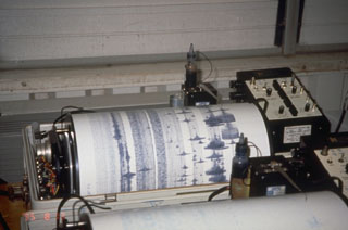 A seismogram at the Montserrat Volcano Observatory registers a volcano-tectonic earthquake swarm on August 12, 1995, several weeks after the start of a long-term eruption. Seismic monitoring is one of several tools used to help predict future eruptions and keep tabs on ongoing activity.
Photo by Cynthia Gardner, 1995 (U.S. Geological Survey).
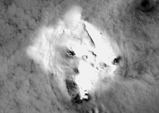
 Thule (left) and Cook (right) islands are seen surrounded by ice floes in this ASTER satellite image. Douglas Strait, the ice-free area in the center of the image, is underlain by a 4.3 x 4.8 km wide caldera between the two volcanic islands. A third stratovolcano forms Bellingshausen Island, just out of view to the right. The Thule Islands lie at the southern end of the South Sandwich island arc bordering the Scotia Sea and consist of three stratovolcanoes constructed along an E-W-trending line.
 ASTER satellite image, 2003 (National Aeronautical and Space Administration, courtesy of ASTER science team).
 Glaciers descend the steep southern face of Visokoi Island from the flat-topped summit of Mount Hodson. Wordie Point (left) and Irving Point (right) lie respectively at the west and east sides of the 5.5 x 7 km wide island. The sea cliffs comprise interbedded lavas and pyroclastics. The cliffs at Wordie Point are formed by thick columnar-jointed lavas. Numerous basaltic scoria cones were constructed on the lower flanks of the island, including at Irving Point, and are thought to represent the most recent activity.
Photo by John Smellie (British Antarctic Survey).
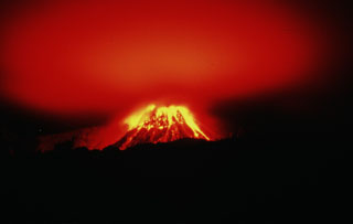 The incandescent lava dome of Soufrière Hills is reflected off the smoke-and-ash column above the volcano on the night of December 26, 1996. The dome is seen here from Long Ground/White's House on the NE flank, 2 km from the summit. This 40-second time exposure captures the paths of incandescent rockfalls and block-and-ash flows during a period characterized by one of the highest magma extrusion rates of the eruption.
Photo by Mark Davies, 1997 (Montserrat Volcano Observatory).
 The rugged, partially forested hill in the foreground is Castle Peak lava dome, formed during an eruption of Soufrière Hills volcano about 350 years ago. The lava dome was emplaced inside the 1-km-wide, horseshoe-shaped English's Crater, whose rim forms the ridge in the background. This was the last known eruption of Soufrière Hills prior to the 1995 eruption. Castle Peak is seen here from the NE on August 20, 1995.
 Photo by Cynthia Gardner, 1995 (U.S. Geological Survey).
 The roughly 2-km-wide, 3 km2 Nightingale (lower), Middle, and Stoltenhoff (top) islands in the South Atlantic Ocean are shown in this January 2018 Planet Labs satellite image monthly mosaic (N is at the top). The heavily eroded Island is the southernmost of the Tristan da Cunha group, and a submarine eruption occurred in 2004.
Satellite image courtesy of Planet Labs Inc., 2018 (https://www.planet.com/).
 The surface of the nearly 14-km-wide Ascensión Island is composed of mafic and felsic eruptive products including scoria cones, lava flows, and pyroclastic flow deposits, some of which are seen in this July 2020 Planet Labs satellite image monthly mosaic (N is at the top). The larger, eroded edifice in the SE is Green Mountain with White Hill farther E. Numerous scoria cones with summit craters are visible across the island.
Satellite image courtesy of Planet Labs Inc., 2020 (https://www.planet.com/).
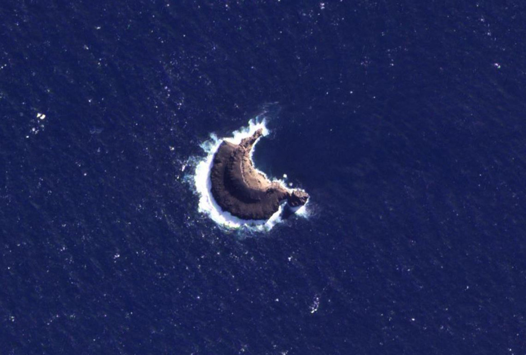
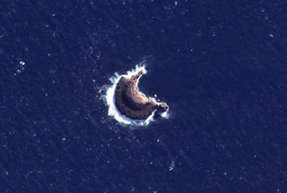 The 1-km-wide (maximum E-W direction) Leskov Island is shown in this 19 March 2021 PlanetScope satellite image (N is at the top). The island is the surface manifestation of a seamount chain that extends 60 km SW of Zavodovski in the South Sandwich Islands and is the smallest of the island group. The island coastline is entirely cliffs and it is constructed of eroded lava flows.
Satellite image courtesy of Planet Labs Inc., 2021 (https://www.planet.com/).
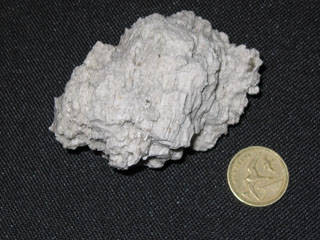 This pumice block, with a one-pound coin for scale (diameter ~24 mm), was collected from the ocean surface near Tristan da Cunha on 3 August 2004. An earthquake swarm lasting 6 hours beginning on 29 July was felt on the island and followed by observations of large blocks of floating pumice.
Photo by Vicky Hards, 2004 (British Geological Survey, copyrighted NERC).
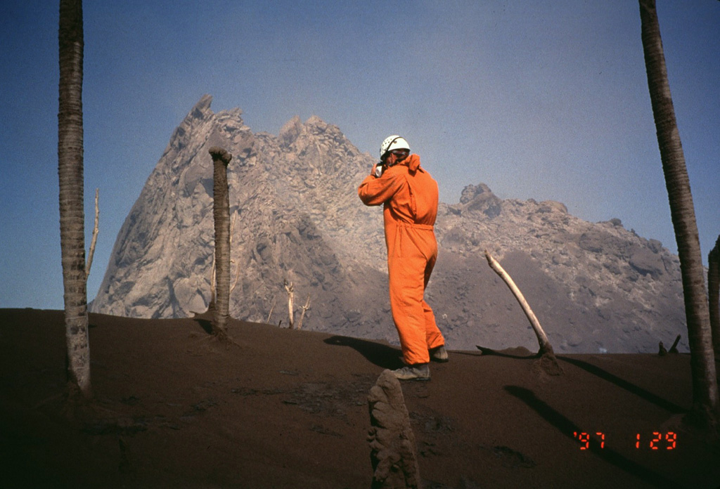
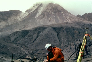
 Volcanologist Richard Heard of the Montserrat Volcano Observatory observes the new lava dome in February 1997. The surface temperature of the lava dome at this time was 650-800 degrees centigrade. By this time the new dome had grown to a height above that of Chances Peak, the former summit of the volcano and the location of this photo. A steep-sided spine forms the northern side of the lava dome. Periodic spine extrusion and subsequent collapse occurred frequently during the eruption.
 Photo by Mark Davies, 1997 (Montserrat Volcano Observatory).
 A Montserrat Volcano Observatory scientist observes the growing lava dome at Soufrière Hills on February 29, 1997. A lava spine, informally referred to as the whaleback spine, caps the dome and was one of many spines that grew and collapsed during the course of growth of the lava dome. Ejecta from explosive eruptions has denuded trees of leaves at Chances Peak in the foreground, west of the lava dome. Chances Pond (lower left), located along the western rim of the summit crater, existed prior to the 1995 eruption.
Photo by Mark Davies, 1997 (Montserrat Volcano Observatory).
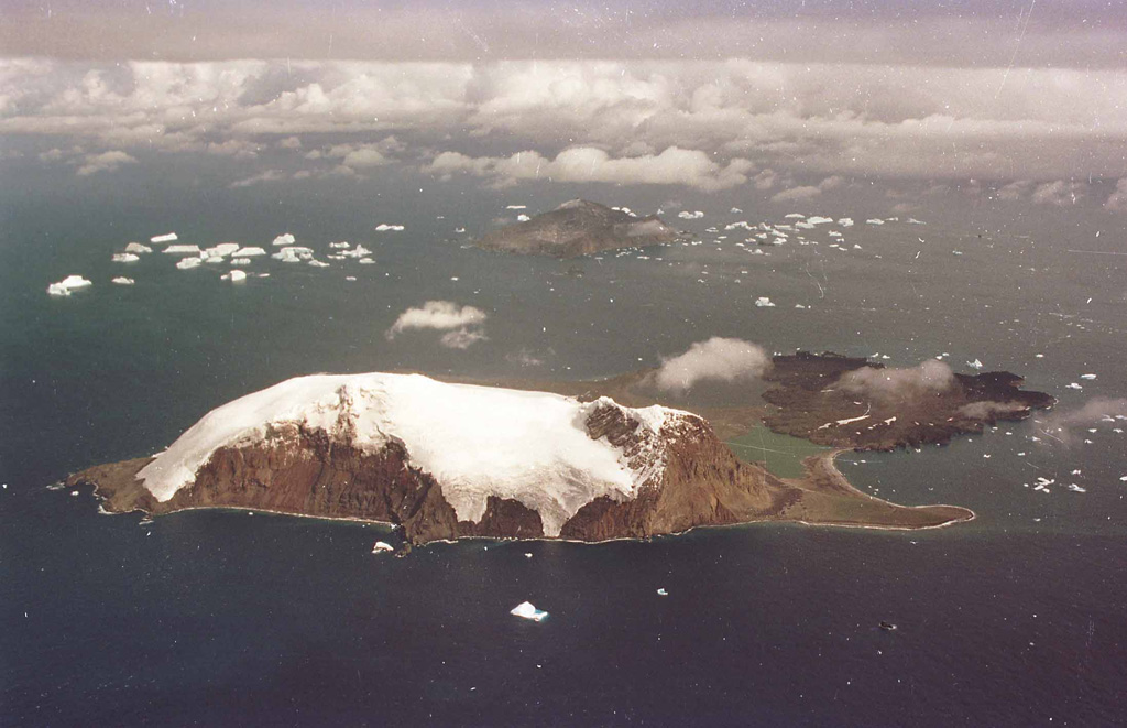
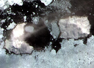
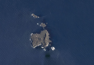
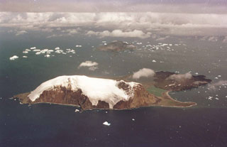
 The southern end of Candlemas Island (upper right) consists of an eroded, glacier-covered stratovolcano whose lava flows may have originated from a former summit vent located east of the island. The snow-free area at the NW part of the island is Lucifer Hill, a scoria-cone complex that was the source of snow-covered lava flows seen in this image. Geysers and hot pools have been observed on several occasions during the 20th century. Vindication Island (lower left), of possible Holocene age, is located 4.5 km west of Candlemas Island.
 ASTER satellite image, 2001 (National Aeronautical and Space Administration, courtesy of ASTER science team).
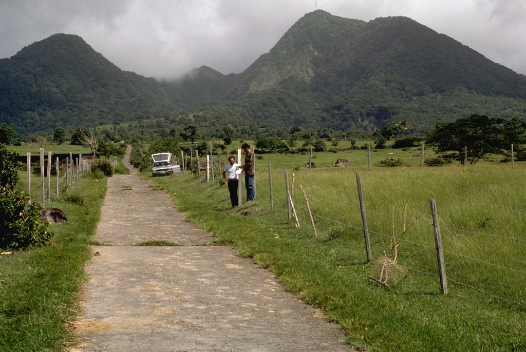
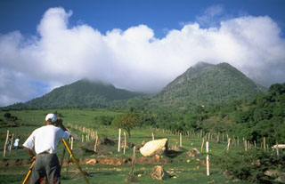
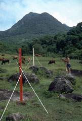 Scientists take precision leveling measurements on the west flank of Soufrière Hills volcano on Montserrat Island in 1985. These measurements, made prior to an eruption that began in 1995, provided baseline data essential for detecting deformation of the volcano associated with the eruption. The cattle in this pastoral scene are grazing on the boulder-littered surface of pyroclastic-flow deposits from earlier eruptions of Soufrière Hills. The hill in the background is Gage's lava dome, the NW-most of a series of lava domes in the summit region.
Photo by Richard Fiske, 1985 (Smithsonian Institution).
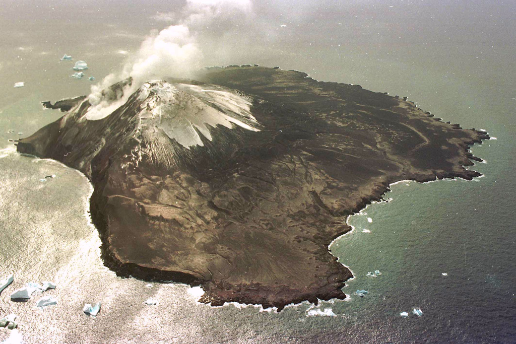
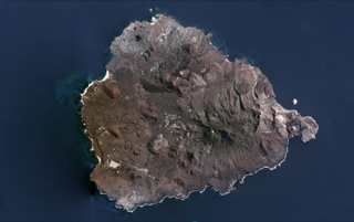
 The largely glacier-covered, 9 x 10 km Bristol Island is one of the largest of the South Sandwich Islands. Both summit and flank vents on Bristol Island have been active during historical time. The latest eruption, during 1956, originated from the west-flank crater, and deposited cinder over the icecap. The extensive icecap on Bristol Island and the difficulty of landing make it the least explored of the South Sandwich Islands.
 ASTER satellite image, 2002 (National Aeronautical and Space Administration, courtesy of ASTER science team).
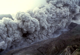
 An ash plume expands above a pyroclastic flow sweeping down the E flank of the Soufrière Hills summit lava dome on 16 January 1997. The pyroclastic flow descended the Tar River valley to the sea, covering the new delta with new material that included blocks up to 5 m in diameter.
Photo by Richard Herd, 1997 (Montserrat Volcano Observatory).
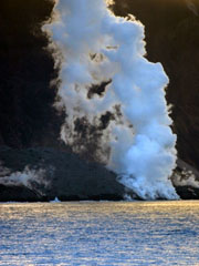 Steam rises from lava flows entering the ocean on the north side of Montagu Island on 13 January 2006. Satellite imagery showed that the lava flow had reached the north coast in September 2005 and began forming a new lava delta.
Photo courtesy of Dave Hall, Frikkie Viljoen and Ian Hunter, 2006 (SA Argulhas and South African Weather Service.
 This 13 January 2006 view of the north side of Montagu Island shows the lava field formed by a recent eruption. A plume rising above Mount Belinda appears to be dominantly composed of steam. The snaking plume of steam in front of the cone likely indicates the location of hot lava flow. There was no record of Holocene activity at Montagu until satellite data, beginning in late 2001, revealed thermal anomalies consistent with lava lake activity.
Photo courtesy of Dave Hall, Frikkie Viljoen and Ian Hunter, 2006 (SA Argulhas and South African Weather Service).
 Pyroclastic flows sweep down the NE flank of Soufrière Hills volcano in December 1997 towards the abandoned airport. During 1997, pyroclastic flows reached the coast of the island on the NE, SW, and western sides. The former capital city of the island, Plymouth, and many other villages were overrun by these high-temperature pyroclastic flows.
Photo by Peter Francis, 1997 (Open University).
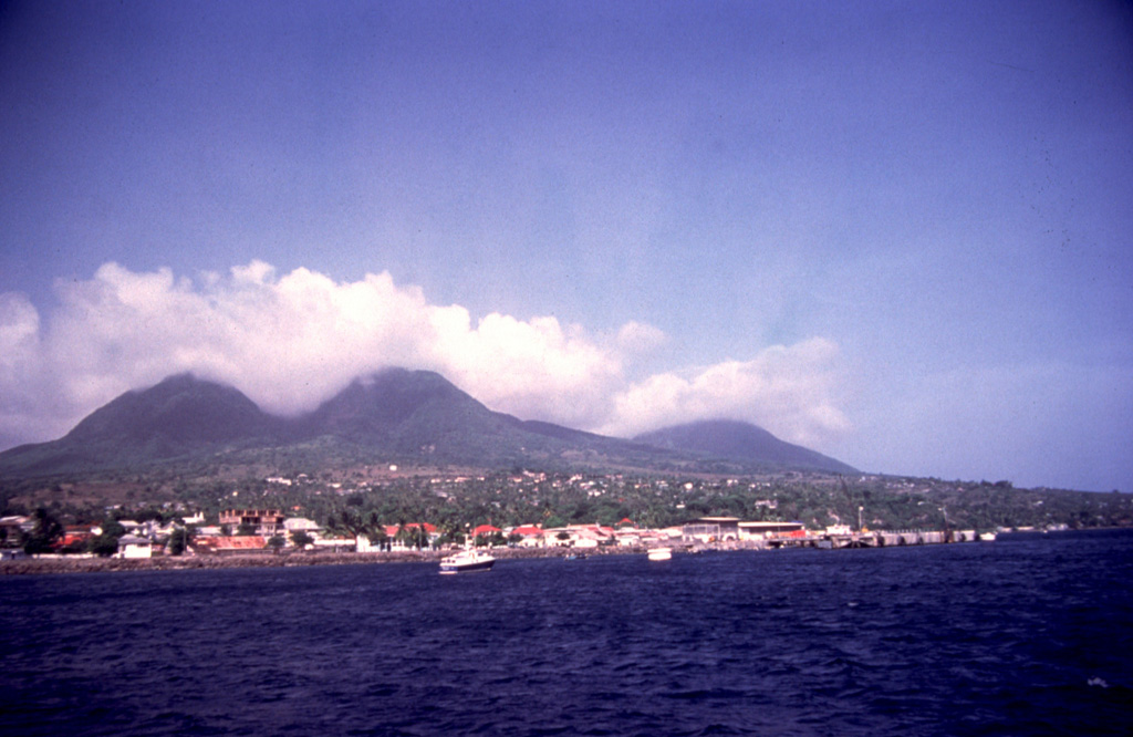
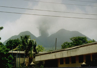
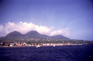 A boat offshore from the former capital city of Plymouth provides a tranquil view of the cloud-draped summit of Soufrière Hills volcano. The photo was taken in 1994, the year prior to the onset of a major eruption from Soufrière Hills that in 1997 destroyed the city of Plymouth. The broad low-lying area the city was built on, only 3-4 km from the summit of the volcano, was one of the few flat-lying areas on the small island of Montserrat and had been created by the products of earlier eruptions similar to those that later destroyed the city.
Photo by Lydia Pulsipher, 1994 (University of Tennessee).
 Volcanologist Richard Robertson of the Montserrat Volcano Observatory makes precision leveling measurements on the west flank of Soufrière Hills volcano on August 19, 1995. Measurements such as these enabled scientists to track the progress of the eruption. The boulders in the foreground are on the surface of pyroclastic-flow deposits from previous eruptions. Gage's Mountain lava dome forms the peak at the right.
Photo by Cynthia Gardner, 1995 (U.S. Geological Survey).
 This 7 December 2003 ASTER satellite image shows Montagu island with recent volcanic deposits visible across the icy surface of the island from Mount Belinda. The smooth ice and snow south of Belinda reflects 6 km wide caldera. A dark lava flow can be seen extending NE from the summit vent (towards the top). The dark feature extending south from the summit (towards the bottom right) is the shadow of a small ash plume rising to the southeast. Ash deposits are visible in a fan right of the central vent (E).
ASTER satellite image, 2003 (National Aeronautical and Space Administration, courtesy of ASTER science team).
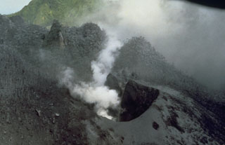
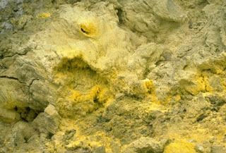 Sulfur crystals are deposited around fumarolic vents at Galway's Soufrière on the south flank of Soufrière Hills volcano. Pyroclastic flows from a growing lava dome spilled over the south rim of the summit crater down the White River Ghaut valley and buried this frequently visited fumarolic area in April 1997.
Photo by Lee Siebert, 1977 (Smithsonian Institution).
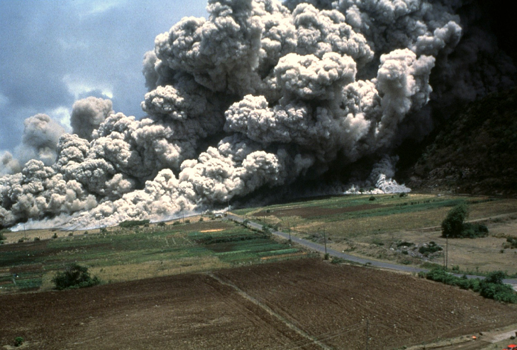
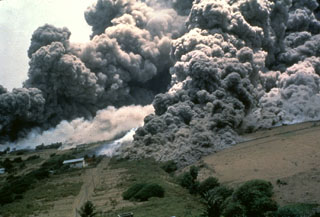
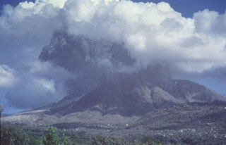
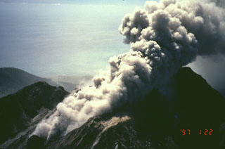
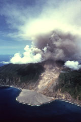
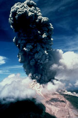 An ash cloud towers above Soufrière Hills in October 1997 as pyroclastic flows descend the volcano's flanks. This was one of a series of 61 explosive eruptions that occurred during a period of high activity between September 28 and October 21. Explosions occurred at an average interval of 8.5 hours. The largest explosions, October 20-21, produced eruption columns to heights of 9 km. Pyroclastic flows accompanying many of the explosions traveled down all sides of the volcano, but were preferentially directed to the north.
Photo by Peter Francis, 1997 (Open University).
 Soufrière Hills volcano towers above the peaceful city of Plymouth in 1994, the year prior to the onset of the devastating eruption that eventually destroyed the former capital city. Pyroclastic flows from a growing lava dome swept through the city to the sea in August 1997 through the low notch (center) in the western crater wall of the volcano. The city was located only 3 km from the crater rim on top of flat-lying pyroclastic-flow deposits from previous eruptions.
Photo by Lydia Mihelic Pulsipher, 1994 (University of Tennessee).
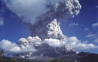 A towering ash cloud rises above the summit of Soufrière Hills volcano on October 20, 1997, as pyroclastic flows sweep down the flanks of the volcano. This photo was taken from the old volcano observatory 7 km NW of the volcano two minutes after the start of the explosion.
Photo by Paul Cole, 1997 (Montserrat Volcano Observatory).
 Steam clouds rise from fumaroles near the summit of Mount Curry, on Zavodovski Island, in this aerial view from the south. Icebergs lie off the shores of the approximately 4.5-km-wide island, the northernmost of the South Sandwich Islands. The eastern coast (right) comprises lava flows and is low-lying, contrasting with the cliffs of the west (left). Two young eruptive fissures extend NE from the summit toward craters on the east flank and were the source of a lava platform extending toward Pungent Point (right).
Photo by HMS Endurance (courtesy of John Smellie, British Antarctic Survey).
 Gage's Mountain (left) and Chance's Mountain (right), seen here from the west in 1985, are the NW-most of a series of lava domes forming the summit of Soufrière Hills volcano. They are among the oldest of the summit domes, and were formed during the late Pleistocene. Pyroclastic flows that reached Plymouth in 1997 traveled down Gage's Ghaut, the valley between the two lava domes.
Photo by Richard Fiske, 1985 (Smithsonian Institution).
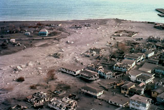 Pyroclastic flows and surges repeatedly swept through Plymouth, the former capital of Montserrat, beginning in August 1997. This December 1997 photo shows the deserted city mantled by ash, with buildings partially or totally destroyed by the high-temperature pyroclastic flows. Continued growth of the summit lava dome during 1997 had filled in the summit crater, which caused pyroclastic flows to spill over the western crater rim and travel down the Fort Ghaut valley into the evacuated city.
Photo by Peter Francis, 1997 (Open University).
 The glacier-covered peaks of Mount Andromeda (Ieft) and Mount Perseus (right) rise along the eastern side of Candlemas Island. Rocky beaches join this prominent southern part of the island to a low-relief ice-free area consisting of dark lava flows from Lucifer Hills in the north. Lucifer Hills is a complex of coalesced cinder cones with numerous active fumaroles, and dark clouds were seen emanating from the area in 1823 and 1911, indicating recent eruptions. A narrow spit, Demon Point, divides greenish Gorgon Pool from Kraken Cove (right). Medusa Pool lies below the cloud beyond Gorgon Pool. Vindication Island can be seen in the background, about 4.5 km from Candlemas. These two islands are part of the same volcanic edifice, with Vindication Island representing the oldest parts of the volcano.
Photo by HMS Endurance (courtesy of John Smellie, British Antarctic Survey).
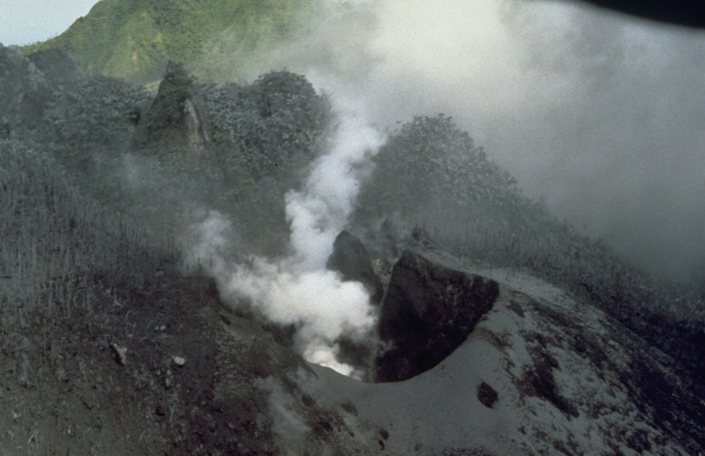
 The first explosion of the eruption of Soufrière Hills that began in 1995 blasted a new crater on the NW side of Castle Peak lava dome in the center of English's Crater. Steam rises from the new crater in this August 4, 1995, view from the NW, and a coating of gray ash blankets vegetation around the vent. A second crater was formed on July 28 on the SW side of the dome. It was one of several that were created during phreatic eruptions that preceded growth of a new lava dome beginning in November 1995.
Photo by Tom Casadevall, 1995 (U.S. Geological Survey).
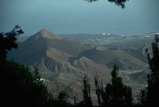 A view to the NW from Green Mountain shows The Sisters (left) and Perfect Crater (right-center), cinder cones on the flanks of the Ascensión Island volcano, which lies just west of the Mid-Atlantic Ridge. The isolated island contains numerous cones and lava domes. Many volcanic features on Ascensión have a very youthful appearance, and three eruptions have been dated within the past 2,000 years, the most recent being the South Sisters flow, possibly only 500 years old.
Photo by Jon Davidson (University of Durham).
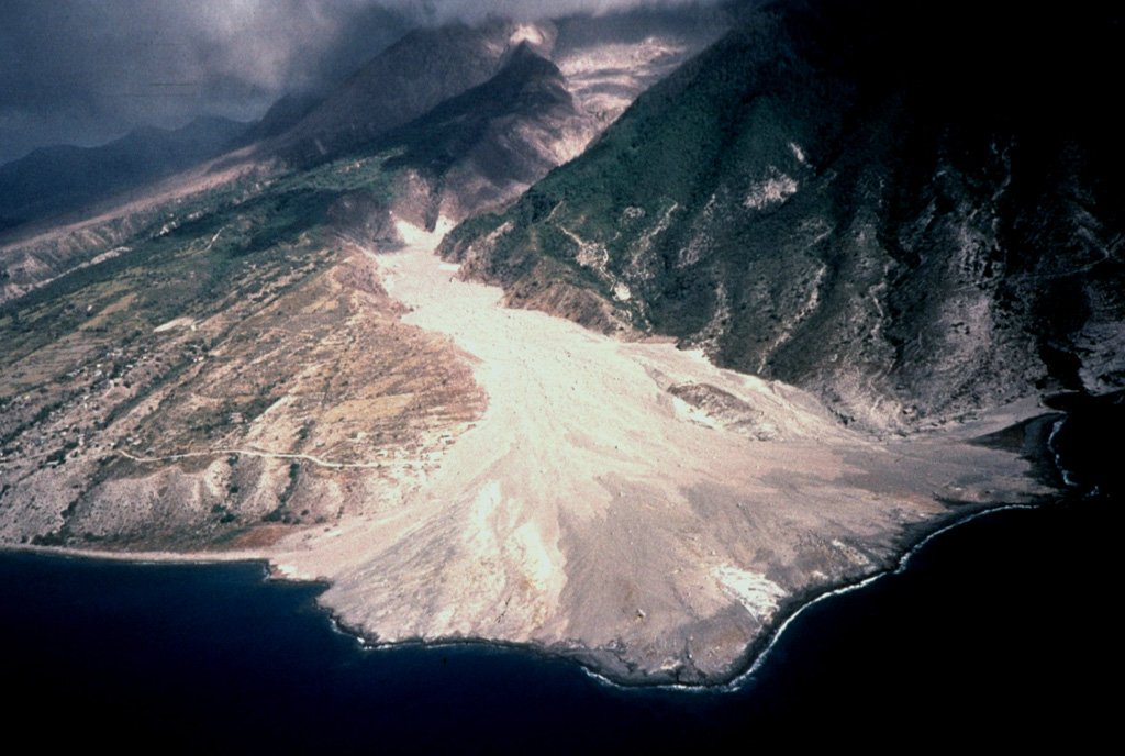
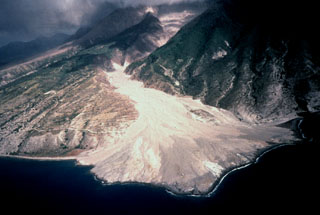 The second of two large deltas formed by the accumulation of pyroclastic-flow deposits is located at the mouth of the White River valley on the southern flank of Soufrière Hills volcano. The pyroclastic flows spilled over a notch on Galway's wall on the southern rim of the summit crater and traveled down the White River, diverging around the flank of the older South Soufriere Hills volcano (right). The accumulated pyroclastic-flow deposits buried Galway's Soufrière, a thermal area on the upper flank, and the evacuated town of O'Garra's on the coast.
Photo by Peter Francis, 1997 (Open University).
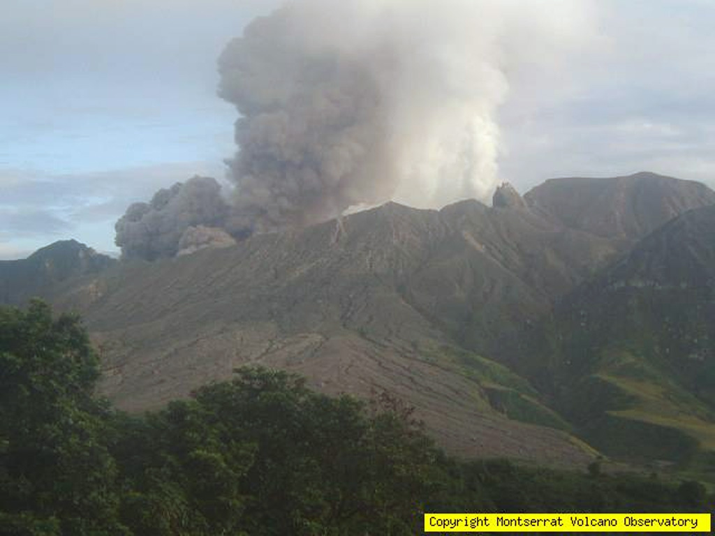
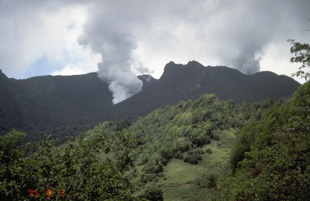
 An ash cloud rises above the southeastern slopes of Soufrière Hills volcano on November 24, 2005. After a quiescent period of almost a year, ash eruptions had resumed at Soufrière Hills on April 15, 2005. Intermittent explosive eruptions continued, and pyroclastic flows were first reported on June 28. Renewed lava dome growth was first observed on August 6. Dome growth and explosive activity continued into the following year.
Photo courtesy of Montserrat Volcano Observatory, 2005.
 Steam rises from two vents formed in the early stages of an eruption of Soufrière Hills volcano that began on July 18, 1995. The plume from the July 18 vent rises above Castle Peak lava dome on the right skyline. The vigorous plume on the left is from a vent formed on July 28 in the moat between the dome and the south wall of English's Crater. Several more craters were formed prior to the onset of growth of a new lava dome in November 1995.
Photo by Cynthia Gardner, 1995 (U.S. Geological Survey).
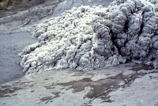 The roiling front of an advancing pyroclastic flow sweeps down the Tar River delta on January 16, 1997. The cauliflower-like clouds of hot gas and ash rise above a basal bedload of vesiculating blocks and pumice from the summit lava dome. This was one of many pyroclastic flows produced by multiple collapses of the oversteepened dome growing in the summit crater of Soufrière Hills volcano.
Photo by Richard Herd, 1997 (Montserrat Volcano Observatory).
 The summit of Soufrière Hills volcano towers above the streets of Plymouth, the capital city of Montserrat Island. Plymouth is located only 4 km west of the volcano, on relatively flat pyroclastic-flow deposits from previous eruptions. This photo was taken in August 1995, shortly after the start of a long-term eruption that severely impacted the island. A lava dome that grew above the height of the crater rim produced pyroclastic flows that by August 1997 swept into the sea through the center of the evacuated city of Plymouth.
 Photo by Cynthia Gardner, 1995 (U.S. Geological Survey).
 A dark ash column rises into light-colored weather clouds surrounding Soufrière Hills volcano. This photo was taken on October 20, 1997 from the old volcano observatory 7 km NW of the summit about a minute after the onset of the explosion. Partial collapse of the eruption column soon produced pyroclastic flows that descended the eastern and western flanks. During the course of the eruption that began in 1995 the volcano observatory had to be moved farther away from the volcano several times as the risk from eruptions increased.
Photo by Paul Cole, 1997 (Montserrat Volcano Observatory).
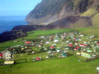 A lava flow on Tristan da Cunha extends approximately 700 m to the sea from a small lava dome formed during the eruption of 1961-1962. The flow is seen here from the SW with the island's only habited area, the village of Edinburgh of the Seven Seas, in the foreground. The eruption began on 10 October 1961 and prompted the evacuation of the island's entire population to England. The eruption ended on 15 March 1962, and resettlement began in September of that year.
Photo by Vicky Hards, 2004 (British Geological Survey, copyrighted NERC).
 A pyroclastic flow descends the upper part of the Tar River valley on Soufrière Hills volcano as seen from the NE on November 22, 2005. During renewed activity beginning in April 2005, pyroclastic flows were first observed on June 28. Following period of rapid lava dome growth beginning on November 4, pyroclastic flows became more common. On November 4 a pyroclastic flow down the Tar River valley reached to within a kilometer of the sea.
Photo courtesy of Montserrat Volcano Observatory, 2005.
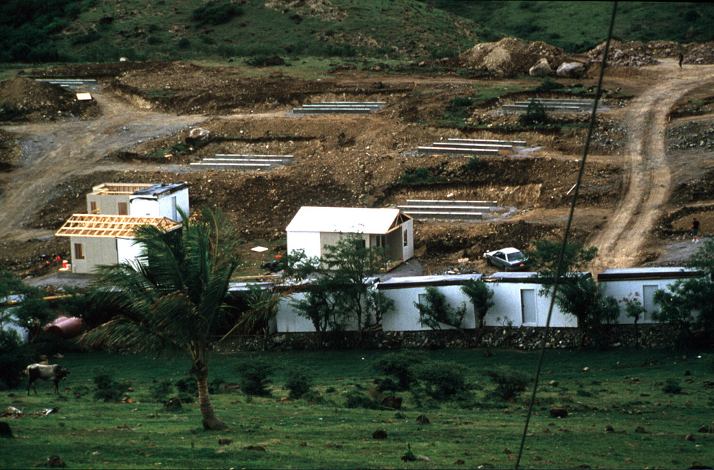
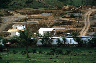 The Soufrière Hills eruption progressively impacted larger proportions of Montserrat. The eruption imposed severe hardships as more and more of the heavily populated southern half of the island became uninhabitable. Eventually more than half of the island's 11,000 residents left to other West Indies islands, or to England, but more than 4000 people elected to remain on Montserrat. These prefabricated houses were being constructed in September 1997 to house refugees at Davy Hill, on the northern side of the island.
Photo by Lydia Mihelic Pulsipher, 1997 (University of Tennessee).
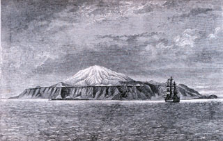 The HMS Challenger lies off Tristan da Cunha island in this 1878 plate from "The Voyage of the Challenger." This converted military vessel was outfitted for scientific surveys and circumnavigated the globe over 3.5 years. The island can be seen to comprise a tall central volcano rising above steep coastal cliffs that truncate lava flows. Pyroclastic cones are shown on the flanks.
 Plate from Thomson, 1878 (courtesy of NOAA Photo Library).
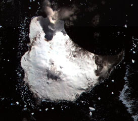
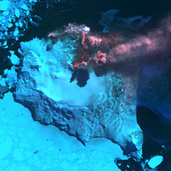 An ASTER satellite infrared image shows Montagu Island's Mount Belinda in eruption on 23 September 2005. A reddish dot (center) marks a thermal anomaly representing an active lava lake at the summit vent. An ash plume rising above the cone casts a shadow on the glacier and is blown eastward by prevailing winds. An active lava flow extends northeast of the vent, before turning to the north and entering the sea on the north coast of the island. Steam clouds are visible where the flow reaches the sea. The eruption was first detected using thermal anomalies detected by satellite instruments in October 2001. Sea ice partially surrounds the island.
ASTER satellite image courtesy of Hawaii Institute of Geophysics and Planetology (HIGP) Thermal Alerts Team, 2005.
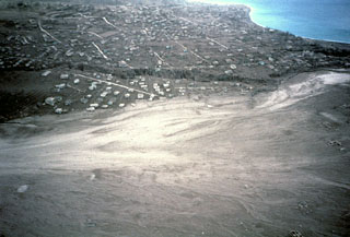 A broad plain of light-colored pyroclastic-flow deposits in the foreground partially buries the city of Plymouth, the former capital of Montserrat. This December 1997 aerial view from the north shows Fort Ghaut valley, completely filled by pyroclastic-flow deposits, cutting diagonally across the center photo. Sugar Bay lies at the upper right, just south of the port of Plymouth. Pyroclastic flows began entering Plymouth in August 1997.
Photo by Mark Davies, 1997 (Montserrat Volcano Observatory).
 Scientists from the Montserrat Volcano Observatory make monitoring measurements in February 1997 as small rockfalls descend the flanks of the lava dome. Castle Peak lava dome, constructed during the previous eruption of Soufrière Hills during the 17th century, had collapsed three days before this photograph was taken from the Tar River Estate house, 2 km NE of the dome. Periodic collapse of the growing lava dome produced pyroclastic flows that in some cases reached the sea.
Photo by Mark Davies, 1997 (Montserrat Volcano Observatory).
 Castle Peak lava dome, on the right skyline, was formed about 350 years ago during the last eruption of Soufrière Hills volcano prior to the 20th century. Seen here in 1977 from the Tar River valley on the east side of the volcano, the Castle Peak dome was constructed within a 1-km-wide horseshoe-shaped crater, whose southern wall forms the left skyline. The high point at the left is Perche's Mountain lava dome.
Photo by Richard Fiske, 1977 (Smithsonian Institution).
 An ash column rises above Soufrière Hills volcano in January 1997. Intermittent phreatic eruptions began at Soufriere Hills on July 18, 1995. A new lava dome started growing in English Crater in September 1995 and eventually filled much of the crater. Pyroclastic flows accompanying dome growth initially were restricted to the eastern flanks, but eventually traveled in all directions, making the entire southern half of the island uninhabitable. In August 1997, pyroclastic flows destroyed much of Plymouth, the former capital of Montserrat.
Photo by Mark Davies, 1997 (Montserrat Volcano Observatory).
 An ash plume rises above the summit of Soufrière Hills volcano on July 19, 1995, the day after the start of a major eruption that began in 1995. This view was taken from the center of Plymouth, the capital city of Montserrat, which is located along the west coast only 4 km from the summit. The eruption column is originating from a vent on the flank of a lava dome inside English's Crater.
Photo by Micole and Adam Dennis, 1995.
 A diffuse ash column rises above the summit of Soufrière Hills volcano on April 2, 1997. The prominent delta seen in this aerial view from the NE was created by pyroclastic flows that descended to the eastern coast down the Tar River valley. The pyroclastic flows were produced by periodic collapse of a lava dome growing in the summit crater, which is breached to the east. The eruption began in July 1995; pyroclastic flows first reached the sea a year later.
 Copyrighted photo by Stephen O'Meara, 1997.
This is a compilation of United Kingdom volcano information sources, such as official monitoring or other government agencies.
| Volcano Observatories | |
|---|---|
| Montserrat Volcano Observatory (MVO) | |
| Volcanic Ash Advisory Center | |
|---|---|
| London Volcanic Ash Advisory Centre (VAAC) | |
| - London VAAC Archive | |
| - London VAAC Notices | |